Department Menu
Education and Outreach
What is Stormwater?
Every time it rains some of the water seeps into the ground, but some of the water is unable to and becomes “stormwater runoff”. Rainfall will soak into the ground, particularly if the land cover is vegetated or has a tree canopy. Developed areas increase the amount of surfaces (i.e., driveways, parking lots, roofs, sidewalks and roads) that prevent water from soaking into the ground. When less of the rainfall can soak into the ground, surface runoff generally increases, sometimes significantly. Increased runoff contributes to higher peak flows in drainage systems and receiving streams, as well as higher runoff volumes. Higher peak flows and volumes contribute to urban stormwater management challenges, including flooding safety hazards, property damage and impacts to surface water quality and stream health.
Stormwater management has become an increasingly important responsibility for local governments. Like other counties, Rockdale County has traditionally managed stormwater runoff by collecting and channeling it through its stormwater sewer system: catch basins on the side of roadways, underground pipes, junction boxes and ponds before it is released into our rivers, creeks and streams.
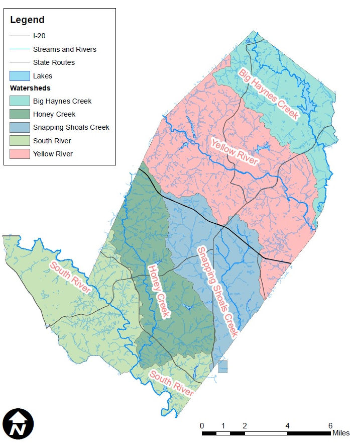
This stormwater runoff drains to the lowest point in the land area based on topography, known as a “watershed”. A watershed is when water “sheds” from the land after the rain falls and snow melts. Drop by drop, water is channeled into soils, groundwaters, creeks and streams making its way to larger rivers and eventually the sea. “Pervious” surfaces, such as grass land cover, allow rain water to seep into the ground. Due to development, there is an increased amount of “impervious” surfaces where water is not able to soak into the soil. If no businesses, streets and houses were in Rockdale County, then the water would flow as stated, but the County has stormwater infrastructure (stormwater sewer systems) in place to aid in transporting the rain water where it needs to go. All stormwater entering Rockdale County’s storm sewer system or a drainage ditch is released directly into bodies of water used for swimming, fishing and drinking.
Stormwater runoff can pick up pollutants such as: debris, litter, trash, dirt, leaves, grass clippings, sediment, pesticides, fertilizers, oil, grease, chemicals, pet waste and other contaminants as it runs off developed land. This polluted water is “non-point source” pollution, because there are many sources contributing to the pollution. In contrast, “point source” pollution originates from a single identifiable source such as a pipe from a wastewater treatment plant or a pipe from an industrial facility. Everything that happens in the watershed – development, pollution, erosion, flooding – has the potential to affect the health and stability of our water, so proper stormwater management and watershed management is essential.
Rockdale County has five major watershed districts: Big Haynes Creek, Yellow River, Honey Creek, Snapping Shoals Creek and South River.
Impaired Waters
The federal Clean Water Act requires each state to maintain a list of waters that do not meet water quality standards. Water quality standards (WQS) are risk-based requirements which set site-specific allowable pollutant levels for individual water bodies, such as rivers, lakes, streams and wetlands. States set WQS by designating uses for the water body (e.g., recreation, water supply, aquatic life, agriculture) and apply water quality criteria (numeric pollutant concentrations and narrative requirements) to protect the designated uses.
Every waterbody in Georgia has one or more designated uses. Examples of specific designated uses are “fishing”, “recreation” and “drinking water”. The State has adopted water quality criteria to protect these uses. For instance, the State has determined that for a water to support its use of fishing, it must have a daily average dissolved oxygen concentration of at least 5.0 mg/l and a minimum of 4.0 mg/l. Some other examples of parameters that have water quality criteria are pH, fecal coliform bacteria, temperature, metals, sediment and certain organic pollutants.
The Georgia Environmental Protection Division (GA EPD) determines whether a waterbody is supporting its designated uses by collecting water quality data and comparing this data against the water quality criteria. It is the goal of the State of Georgia that all its waters support their designated uses.
Section 305(b) of the Clean Water Act requires states to assess and describe the quality of its waters every two years in a report called the 305(b) report. Section 303(d) of the Clean Water Act requires states to submit a list of all the waters that are not meeting their designated uses. Water bodies that do not meet applicable water quality standards are placed on the 303(d) list of water bodies not meeting standards. Georgia submits a combined 305(b)/303(d) report to the US EPA every two years. One section of the report is the 305(b)/303(d) list of waters, referred to as the “impaired list”.
Since waterbodies (such as streams and rivers) are typically many miles long, it is usually not feasible to assess a whole waterbody as a single unit. Therefore each waterbody is typically broken into smaller portions called “reaches”. The size of each reach varies. For example, Yellow River is on the impaired list in Rockdale County as two reaches: Centerville Creek to Hammock Creek and Hammock Creek to Big Haynes Creek. These two reaches have different parameters for why they are on the impaired list.
Every two years GA EPD gathers data that has been collected across the State. The data comes from a number of sources including GA EPD, other state agencies, such as the Wildlife Resources Division and Coastal Resources Division, federal agencies, such as the US Geological Survey and local governments and environmental groups. The water quality data are compared to the State’s water quality criteria.
Municipalities, like Rockdale County, conduct regular monitoring and initiate and perform best management practices (BMPs) in order to improve water quality within the County. BMPs for Rockdale County include scheduling public education activities, prohibiting practices, providing operation and maintenance procedures, ensuring treatment requirements, monitoring and source tracing and other techniques to prevent or reduce the discharge of pollutants to surface waters.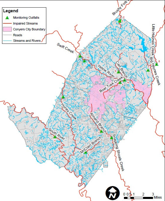
Educational and Informational
Resolution to Set Fees for Stormwater Services (2020)
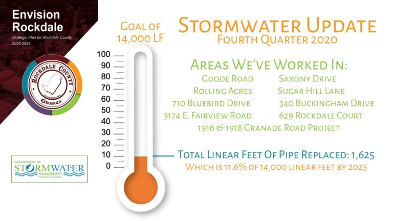
Stormwater Linear Feet of Pipe (Updated 10.20.2020)
Critical Storm Pipes (Updated 10.30.2020)
Illicit Discharge Pollution Prevention (2019)
Stormwater Responsibilities Overview (2019)
Impaired Waters (2017)
OUTREACH
Part of Rockdale County’s stormwater program is to conduct educational outreach programs such as the storm drain stenciling project, cleanup events and educational programs with private groups and schools.
Storm Drain Stenciling Program
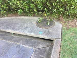
A storm drain marker or stencil is a 4-inch diameter plastic decal with the message “No Dumping, Drains to Stream”. During the storm drain stenciling program, volunteers attach the stencils with glue to local storm drain inlets or structures to remind the general public not to pour or dump anything into storm drains.
The Department of Stormwater Management has implemented a new twist on the existing storm drain stenciling program where volunteers now meet annually at Johnson Park for a fun-filled morning of stenciling drains! Breakfast, t-shirts and snacks are provided for this half-day event of learning about pollution prevention. Volunteers are quickly trained how to stencil drains, then receive their box of equipment full of supplies to get the job done. Girl and Boy Scouts are encouraged to attend, because they receive a patch for storm drain stenciling. This program is a great opportunity for volunteers, businesses, neighborhood associations, students, and youth groups to be a solution to downstream stormwater pollution and to eliminate pollution at its source!
Cleanup Events
Litter is a major source of stormwater pollution in Rockdale County. Therefore, twice a year Keep Conyers-Rockdale Beautiful (KCRB), Rockdale County and the City of Conyers organize community cleanup events in conjunction with the Great American Cleanup in the spring and Rivers Alive in the fall. Both of these events are highly anticipated in our community for those who want to give back through a day of service.
Are you looking for a way to give back to your community? Georgia has more than 68,000 miles of streams and coastline, 4.8 million acres of wetlands and 425,000 acres of public lakes and reservoirs that need your help. Our waterways provide us with fresh drinking water, great recreational opportunities like swimming and fishing, and they serve as a pleasant retreat from our busy lives. This is your opportunity to help protect one of our most precious resources. Please help us clean our rivers, streams, lakes and wetlands by encouraging your co-workers, family and friends to participate in either the Great American Cleanup typically in the spring or the Rivers Alive event
Rockdale County Road Blitz. A joint effort with RDOT to get rid of pollution
Address
Administration and Services Building958 Milstead Ave.P.O. Box 1495Conyers, GA 30012
Office Hours:
8:00 a.m. to 5:00 p.m.
Monday through Friday
Numbers:
Telephone: (770) 278-7155
Email:
rcswu@rockdalecountyga.gov